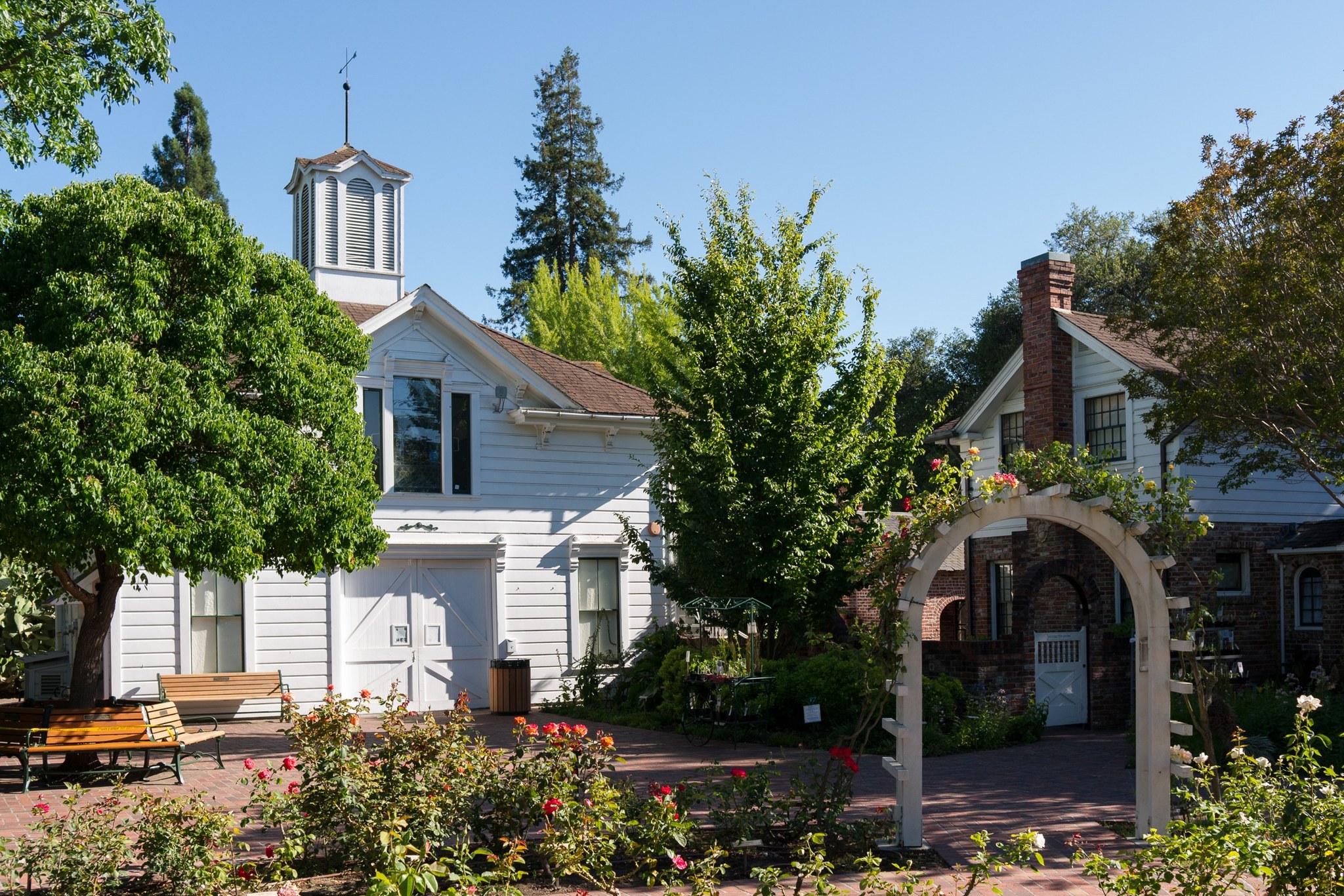
Luther Burbank Home and Gardens in Santa Rosa, photographed in June 2012.

Outdoors

Horseback riding near Santa Rosa

Trails and recreation areas near Santa Rosa open to horseback riding, including horse camps.

8places to ride horses
28 mito the closest
1within 30 miles
Year-roundbest months

Good to know: Check trailer parking and stock water at the trailhead, and whether certified weed-free hay is required.

Closest picks

1

Point Reyes National Seashore Campground

28 mi south · National Park Service

Point Reyes National Seashore offers four backcountry hike in campgrounds and thirteen boat in campsites along Tomales Bay. Note: For reservation purposes, our campgrounds are organized under the "loop" column of the reservation grid.
2

Lake Berryessa

33 mi east · Bureau of Reclamation

Nestled between Blue Ridge and Cedar Roughs, east of the Napa Valley, Lake Berryessa offers year-round recreation opportunities.

3

Cache Creek Wilderness

38 mi north · Bureau of Land Management

The Cache Creek Wilderness now contains a total of 27,294 acres and is managed by the Bureau of Land Management. All of the Wilderness is in the state of California.

Map of all 8 places

Map of 8 places loads as you scroll.

Within 30 miles (1)

28 mi south · National Park Service · Campground

Point Reyes National Seashore Campground

Point Reyes National Seashore offers four backcountry hike in campgrounds and thirteen boat in campsites along Tomales Bay. Note: For reservation purposes, our campgrounds are organized under the "loop" column of the reservation grid.

  • Backpacking
  • Biking
  • Birding
  • Boating
  • Camping
  • Hiking
  • History
  • Horse Camping

30 to 75 miles (7)

33 mi east · Bureau of Reclamation

Lake Berryessa

Nestled between Blue Ridge and Cedar Roughs, east of the Napa Valley, Lake Berryessa offers year-round recreation opportunities.

  • Biking
  • Boating
  • Camping
  • Fishing
  • Hiking
  • History
  • Horseback riding
  • Hotel/Lodge/Resort Fs Owned

38 mi north · Bureau of Land Management

Cache Creek Wilderness

The Cache Creek Wilderness now contains a total of 27,294 acres and is managed by the Bureau of Land Management. All of the Wilderness is in the state of California.

  • Camping
  • Fishing
  • Hiking
  • Horseback riding
  • Hunting
  • Picnicking
  • Water sports
  • Wilderness

39 mi north · Bureau of Land Management

Cache Creek Natural Area

This secluded, hilly expanse of oak woodlands, grasslands, and chaparral is a combination of over 70,000 acres of BLM managed lands and 4,700 acres of State and County lands.

  • Biking
  • Boating
  • Camping
  • Fishing
  • Hiking
  • Horseback riding
  • Hunting
  • Picnicking

41 mi south · National Park Service

Golden Gate National Recreation Area

Experience a park so rich it supports 19 distinct ecosystems with over 2,000 plant and animal species.

  • Biking
  • Camping
  • Fishing
  • Hiking
  • History
  • Horseback riding
  • Picnicking
  • Wildlife viewing

45 mi northwest · Bureau of Land Management

Cow Mountain Recreation Management Area

Please visit the following sites for more information about North and South Cow Mountain. North Cow Mountain Recreation Area South Cow Mountain OHV Management Area

  • Biking
  • Camping
  • Hiking
  • Horseback riding
  • Hunting
  • Off-highway vehicles
  • Picnicking
  • Recreational Shooting

46 mi south · National Park Service · Campground

Aquatic Park Cove, Black Point Overnight Anchoring, Sailing Vessels only (auxiliary engine OK)

Aquatic Park Cove is a vibrantly urban harbor that mimics a natural anchorage and is located on the Pacific shores of one of America's great West Coast cities.

  • Biking
  • Boating
  • Camping
  • Climbing
  • Fishing
  • Hiking
  • History
  • Horseback riding

47 mi north · Bureau of Land Management

Indian Valley Management Area

Note: Click here to view our California State Parks OHV grant preliminary applications . The public comment period will be open from March 4, 2025 to May 5, 2025. Instructions on how to provide public comments can be found here .

  • Accessible Facility Or Activity
  • Camping
  • Fishing
  • History
  • Horseback riding
  • Hunting
  • Off-highway vehicles
  • Recreational Shooting

Distances are straight-line miles from downtown Santa Rosa. Listings come from Recreation.gov’s federal recreation database; check each official page for hours, fees, fire restrictions and closures before you go.

Get outside around Santa Rosa

Fun Things to Do in Santa Rosa, Sonoma County, California video thumbnail

THINGS TO DO · YOUTUBE SHORT

Fun Things to Do in Santa Rosa, Sonoma County, California

An activity Short shared by Sonoma County.

Watch on YouTube ↗

Around Santa Rosa

Hotel La Rose, Downtown Santa Rosa, California,2
Hotel La Rose, Downtown Santa Rosa, California,2Wulfnoth of English Wikipedia · Public domain
Santa Rosa Original Certified Farmers Market - December 2023 - Sarah Stierch
Santa Rosa Original Certified Farmers Market - December 2023 - Sarah StierchMissvain · CC BY 4.0
Frank P Doyle Library, Santa Rosa Junior College
Frank P Doyle Library, Santa Rosa Junior CollegeE bailey · CC BY-SA 4.0

More outdoors near Santa Rosa

Questions

Where is the closest place for horseback riding near Santa Rosa?

Point Reyes National Seashore Campground (National Park Service), about 28 miles south of Santa Rosa as the crow flies. Next are Lake Berryessa (33 mi) and Cache Creek Wilderness (38 mi).

When is the best time for horseback riding near Santa Rosa?

Based on Santa Rosa’s average highs, all year. Conditions at higher elevations can be much cooler.

Who manages these places?

Federal agencies including Bureau of Land Management, National Park Service, Bureau of Reclamation. Each listing links to its official page for hours, fees, closures and current conditions.

Santa Rosa AI

Your Santa Rosa local guide
Hey there!

I'm Santa Rosa AI. Ask about local food, shopping, history or a day out.

AI recommendations may be inaccurate. Verify hours and prices. Questions are processed by Cloudflare. Privacy